What a difference a day makes – satellite images show the unpredictability of the British summer
Published On Wed 20 Jul 2016 by Grant Hill
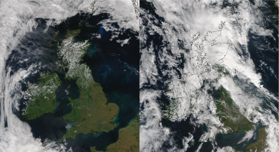
Images captured by the University of Dundee Satellite Receiving Station yesterday and today starkly illustrate the changing nature of the British summer.
While Tuesday, 19th July was recorded as the nation’s hottest day of the year so far, Wednesday 20th saw thunder and lightning storms and heavy rain come to parts of the British Isles.
The side-by-side images (captured by the NPP satellite at 1255 GMT on 19/07/16 and 1237 GMT on 20/07/16 respectively) demonstrate how things changed in 24 hours.
The images are free to use but MUST BE CREDITED to 'NEODAAS/University of Dundee'.
For media enquiries contact:
Grant Hill
Press Officer
University of Dundee
Nethergate, Dundee, DD1 4HN
Tel: +44 (0)1382 384768
Mobile: 07854 953277
Email: g.hill@dundee.ac.uk