5 June 2001
Worldwide water use has more than tripled in the last 50 years and the pressures on it continue to mount.
The amount of water which evaporates from a hectare of growing rice is many times greater than from a hectare of scrubland. But just how much greater? If water policy makers knew that, they would be better placed to plan for reservoirs, irrigation and water use.
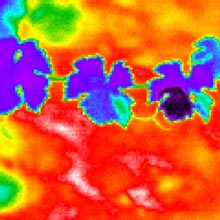
Scientists at the University of Dundee are focussing on the thermal imaging of leaf temperature (picture) to develop new approaches for the measurement of water use by different ecosystems.
Images are obtained at scales ranging from the individual leaf or plant at one extreme to airborne or satellite measurements at the other. Measurements at these different scales are combined to quantify the water vapour given off by different types of vegetation across the drier areas of Europe. This information will be critical to planners who need to manage limited water resources.
"As populations increase, pollution levels rise and global warming takes its toll, water is increasingly under pressure as a resource. In Mediterranean climates water is the most serious problem for agriculture. Now that new EU regulations are about to be introduced in the UK limiting water irrigation, and changes are to be made in the water licensing laws, the need for accurate methods of measuring water systems has never been greater," explains leader of the Dundee team in this international project Professor Hamlyn Jones of the University's School of Life Sciences.
He, and Professor Arthur Cracknell of the University of Dundee's Centre for Remote Sensing and Environmental Monitoring, are joined this week (first week June) by New Zealander Dr Nicole Archer, an expert in Mediterranean hydrology to examine special images received through the Dundee University Satellite Receiving Station and other similar stations. Satellite pictures of vineyards, olive groves, orchards and Portugal's scrubland or montado will be taken using hyperspectral imaging techniques. Meanwhile in a fieldbase in Portugal, researchers will measure what is happening on the ground at plant and soil level. Interpretation of the images, in conjunction with the micrometeorological measurements is expected to cast new light on water use and flow that will be applicable not only to Mediterranean ecosystems but also to those in the UK.
"Through this work we hope to be able to develop techniques which will allow us to take measurements at say a single tree level and scale them up to accurately predict water use across a landscape," said Professor Jones.
The three year Ł130,000 project is funded by the European Commission with additional support for aerial hyperspectral imaging coming from the German Aerospace Establishment./ends
Contact Professor Hamlyn Jones 01382 344720